Supporting network and project planning approaches
Addressing the gap between the current and aspirational network is at the core of network operation planning. The approach of understanding the gap in performance can also be used for the development and assessment of network level programs, as well as project testing and planning. Land use is increasingly being considered as part of network operation planning, particularly through Movement and Place Frameworks.
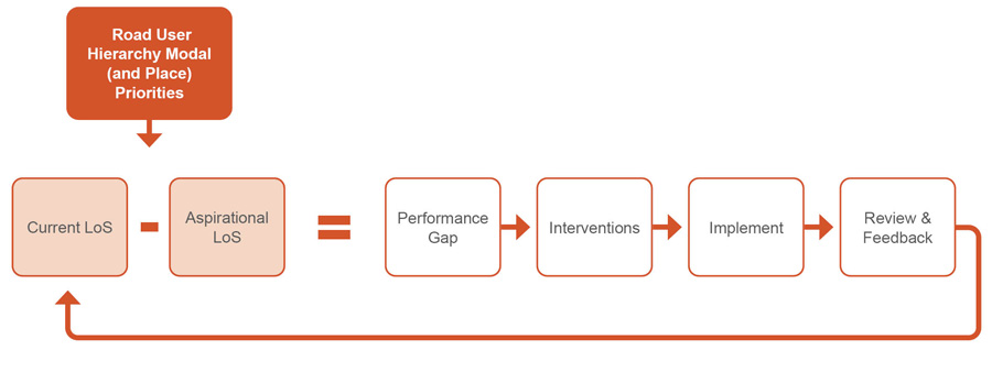
Network operation planning primarily considers how city / state level modal networks currently and should ideally operate at an area / corridor level. Gaps between the current and ideal operation are used to develop and implement suitable interventions, as illustrated below.
Network operating plan gap analysis process
When gap analysis is undertaken at a network wide level, it can be used to inform program and project requirements.
Land use is increasingly being considered. The most recent guidance from New South Wales and Victoria adopts a Movement and Place Framework approach to the classification of city / state level transport networks. This approach classifies each road link (and interchange in Victoria) on their level of Movement and Place function. Movement and Place Frameworks are being developed in most other jurisdictions in Australia and New Zealand.
The Movement and Place Framework is also informing guidance on recommended road and street design treatments. Street families and option toolboxes are being developed to support the use of the Movement and Place Framework in New South Wales and Victoria to help achieve minimum desired levels of operation. Ideally these toolboxes will cover operational measures, as well as road corridor infrastructure elements.
Internationally, there is a push towards more of a healthy living / complete streets approach. This encourages thinking beyond just the function of a road link, to consider how it supports the various users and their activities within a street such as being inclusive, engaged, safe and relaxed.
Source material
Source | Supporting network and project planning approaches |
|---|---|
Outlined through ‘Phase 1 - Network Operations Objectives’ and ‘Phase 2 - Network and Services Definition’ in Figure 2 p18, with write-ups on p19-20. | |
Section 3.2.3 Consideration of ‘Place’ p7 provides the following views from experts consulted on this matter. "The teleconference participants considered the current Framework lacks a strong recognition of ‘place’. Victoria, South Australia and New Zealand are finding the ‘Link and Place’ classification (Jones, Boujenko & Marshall 2007) approach helpful in determining road user priorities (see Adelaide City Council 2012; VicRoads 2011) because it incorporates the importance of ‘place’ into the priorities for each mode."
"The teleconference participants discussed the possibility of a complementary framework which defines the liveability of places in terms of accessibility and amenity. These objectives could not be combined with transport mobility objectives but could be considered at the same time.
Inputs to this phase should also include existing and future land uses/trip generators, key destinations and projected growth of land uses.
Outputs of this phase need to include defining activity centres and key destinations." | |
Signal Management Techniques to Support Network Operations (2015) | Section 3.2.3 - Performance Metrics p8-9 states: "The LOS framework is organised around the identified needs of road users, which are categorised as follows:
|
Section 1 - Introduction p3-5 states: "The key planning principles in an NOP are:
| |
Guide to Traffic Management Part 4: Network Management Strategies (2020) | Section 5 - Network Operation Plan p56-58 states: "An NOP underpins higher level strategic plans. The key planning principles in an NOP are:
|
Covered through Figure 1.1 on p2. |
Source | Supporting network and project planning approaches |
|---|---|
Section 1.4 - Linked objectives p27 states: "Objectives at one level inform and guide the specification of objectives at the next level; high-level transport system objectives are reflected in more detailed objectives at subsequent levels, right down to the 'link' level." "This approach enables planning practitioners to use direction, knowledge and priorities from other levels of planning to inform decision-making in each situation. Specific, localised planning then contributes to achieving higher-order planning and priorities (Queensland Government 2003). With this approach, decisions are more likely to be integrated and consistent. | |
Road Network Planning Urban Design ‘Place’ Character Assessment Methodology and Guidance Notes (2019) | Appendix A, Section 1.4 - Consideration of Movement and Place p8 sets out the intent for the relevant network planning approach to be adopted. Of note in this section is the following: "The Movement and Place Framework introduced within the draft Road Network Plan (2017) aims to deliver a road space that promotes the liveability of places it passes through."
"The basic premise being that both Movement and Place are equally significant, whilst the degree of significance may vary based on the type of road corridor and the scale and importance of the location." |
Evolution of road planning in Victoria p8 states: "The SmartRoads plans were focused on examining current operations of the network. It illustrates which transport modes have priority on the road and at local intersections at different times of the day. The Movement and Place Framework takes a future-focused, multi-modal approach to network planning. It takes into consideration the diverse role places play in planning the types of transport modes appropriate to a local road or street. In this new language, roads and streets are defined by the context of a local place and assigned various ‘movement’ and ‘place’ classifications." | |
What it is section states: "It is also a holistic vision of transport that focuses on moving people and goods, not vehicles, and seeing this by time of day seeing transport as supporting broader community goals balancing the competing demands for limited road space thinking ‘network’ rather than sites or routes." | |
Facilitating Network Operations Planning: A Case Study of the VicRoads SmartRoads Framework (2018) | Section 4.1.1 - Acts as a 'policy broker' p5 states:
"SmartRoads has achieved a well-defined structure, creating consistency by unifying the networks with a common language/terminology to describe multimodal traffic networks. This is important because it harmonises the practice of road traffic management, which leads to consensus building. What is unique about SmartRoads is that it provides a system of consistent terminologies, with consistent priority rules, which are encoded so as long as you classify the route correctly, the output from SmartRoads should be consistent." |
Scope of route strategies section p3 states: "The Government’s vision for transforming the strategic road network is described in the Road Investment Strategy post 2020: Planning Ahead. This vision builds on the five broad aims published in the Road Investment Strategy for 2015-2020: economy, network capability, integration, safety and the environment. Using the evidence from route strategies, we will develop proposals that can help bring Government’s vision for roads to life." |
Source | Supporting network and project planning approaches |
|---|---|
| |
| |
| |
Workshops were held to:
| |
Warrigal Road Movement and Place – Intersection Operating Principles |
|