Auckland – Traffic Management Plan
Overview
This case study consists of a review of the network operation planning aspects of Chapter 27 “Traffic Network Management” in the Auckland Transport Code of Practice (ATCOP). The ATCOP is the overarching document providing a wide range of guidance and standards to ensure that the function, condition and useful service life of transport assets are consistently achieved across the region.
Chapter 27 “Traffic Network Management” is primarily for Auckland Transport staff and their nominated consultants. It covers the three areas listed below and as shown in Figure C.1 to effectively use the existing network in order to reduce costs and understand where certain prioritisation should occur:
- Network Road Safety Plan (road safety focus)
- Network Operation Plan (typical day-to-day operations)
- Network Management Plan (recurrent and non-recurrent event management)
ATCOP Chapter 27 – Network Operation Planning Aspects
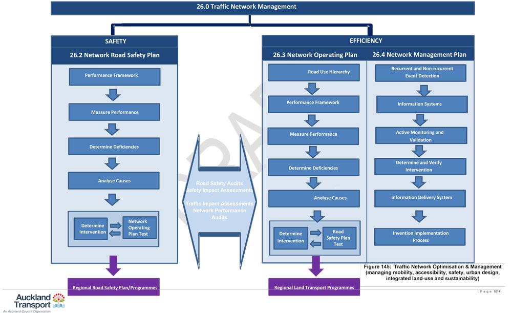
Source: Chapter 27 Traffic Network Management” in the Auckland Transport Code of Practice (ATCOP)
Key Findings
A summary of Chapter 27 of the ATCOP and interview discussions in terms of the network operation planning aspects is provided below.
Theme | Response |
|---|---|
How is "network operation planning" defined and what should it be used for |
|
The development processes / steps / stages and timings |
|
Where it fits in the overall network development and management process |
|
How it aligns / integrates with approval and funding processes | As NOPs have been considered a modal agnostic tool, it has appealed to a wider audience. This has meant increased decision alignment, including with trade-offs with the movement network (place trade-offs have been less agreed too). |
How it aligns / integrates with network and project planning approaches |
|
What the strategic objectives are and where did they come from | The following sets out the ATCOP’s Integrated Transport Planning Approach:
|
What the performance indicators are and where they come from |
|
Who the development team members should be | Not provided |
Who should implement NOPs | As part of the Regional Land Transport Programme process. |
How should it be implemented | Not provided |
What modes have been considered | Road-based modes– including pedestrians, cyclists, transit users, motorized users. |
What network typologies and settings are relevant | Auckland region – area and corridor based operation plans developed. |
Engagement recommendations | Internal and inter-agency engagement activities were conducted. |
Planning and Assessment tools and modelling approaches | Applied the Network Fit Assessment (NFA) tool (SmartRoads) in the following limited settings for specific projects:
|
Required input evidence and data |
|
Monitoring, feedback, update, etc. processes | Not provided |
Documents
The documentation provided as part of this case study included the following:
Chapter 27 Traffic Network Management” in the Auckland Transport Code of Practice (ATCOP)