Albany Highway – Route Operation Plan
Overview
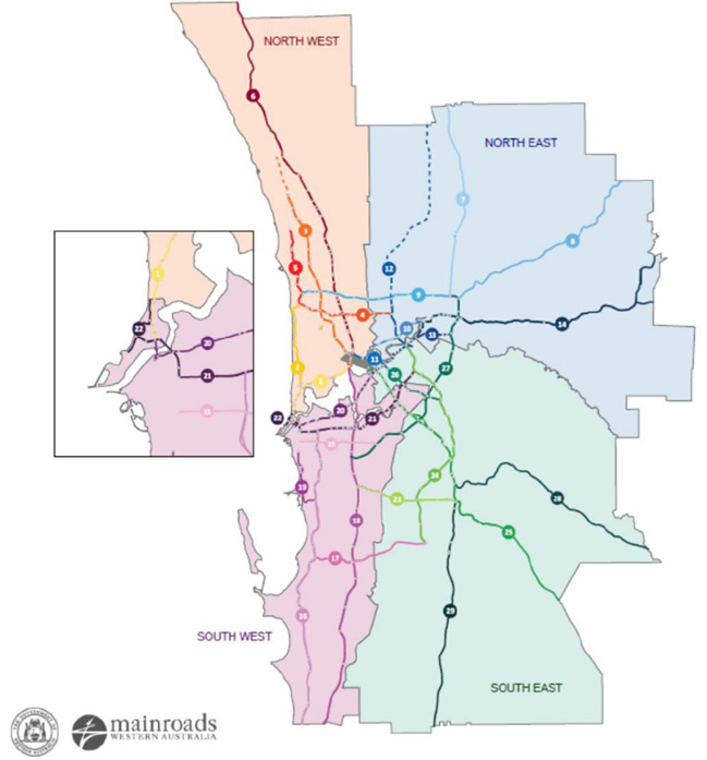
Main Roads Western Australia’s (MRWA) metropolitan state road network comprises 29 routes grouped across four Network Operation Sub-Areas as shown below.
MRWA ROP Routes
A Route Operation Plan (ROP) provides a one-stop-shop reference on the operation conditions of each route. The ROPs do not include specific gap analysis or development of measures to improve operations.
The ROP outputs have been used to assess the state road networks performance, inform proposed programs, and prioritise and assess the implementation of works The Department of Transport is developing a Movement and Place Framework to address some of the limitations identified in the ROPs. Future ROPs will align with this more holistic and integrated approach.
More specifically, the Albany Highway route that forms part of the ROP being reviewed is a 54 km long corridor. It serves as a major south east radial route linking the Perth metropolitan area with regional areas like Albany in the south of the state.
Key Findings
Theme | Response |
|---|---|
How is "network operation planning" defined and what should it be used for |
|
The development processes / steps / stages and timings |
|
Where it fits in the overall network development and management process | Sits under the Perth Transport @ 3.5 Million and Beyond (Transport Plan, RNDP and PTA documents. |
How it aligns / integrates with approval and funding processes | While there are no specific recommendations requiring approval and funding the ROPs do help other programs, projects, and planning decisions:
|
How it aligns / integrates with network and project planning approaches |
|
What the strategic objectives are and where did they come from | Relate to the following MRWA areas of strategic focus (as set out in Keeping WA Moving):
These have then been translated into the following Route Operation strategic objectives:
|
What the performance indicators are and where they come from | In the ROP they are the following:
These are generally used and / or relate to the comparative / relative performance of this route against the others, and the network as a whole. |
Who the development team members should be | The ROPs have been developed within MRWA Operation team and circulated to other departments, including the Network Development Planning team (for long-term strategic planning considerations), Heavy Vehicle Services team (for heavy vehicle operation considerations) and the Public Transport Authority (for public transport considerations). |
Who should implement NOPs |
|
How should it be implemented | The ROPs are intended to inform the development of short-term small-scale improvement schemes under the Pinch Point Program and guide the review objectives of the traffic signal timing reviews undertaken. |
What modes have been considered |
|
What network typologies and settings are relevant | MRWA has a corporate focus around keeping the main road network operating efficiently and safely, so while they will consider area effects, their primary focus is generally a corridor one. |
Engagement recommendations |
|
Planning and Assessment tools and modelling approaches | Network Performance Reporting System (NetPReS[1]) |
Required input evidence and data | IRIS Reporting Centre (for peak volumes, heavy vehicle percentages and all safety statistics) Cost of congestion data is obtained from the NetPReS database. NetPReS (for link efficiency and reliability data): the data is broken into 15-minute intervals for road sections (known as links) that cover all 29 defined routes comprising the metropolitan State Road Network, dating back to 1st January 2013. The next version of this database currently in development will have its scope expanded to include local roads as well. Within NetPReS, the "links" are defined as road sections between successive signalised intersections, or in the case of freeway routes, between on and off-ramps. Links are defined for both inbound and outbound directions relative to Perth's CBD. |
Monitoring, feedback, update, etc. processes | ROPs are generally updated on an annual basis. |
Documents
The documentation provided as part of this case study included the following:
- Route Operation Plan 25 – Albany Highway, MRWA, June 2018