Warrigal Road Movement and Place – Intersection Operating Principles
Overview
With the introduction and application of the Movement and Place Framework in Victoria, the previous SmartRoads based Network Operation Planning approaches have gone through an evolution. Currently, the resulting Network Operation Planning is similar in nature to the SmartRoads processes, but with each link of the network now: being assigned Movement and Place classifications, revised Level of Service measurements for each mode, inclusion of place, safety and environment performance measures, and only a strategic network level gap analysis process (rather than the more detailed Network Fit Assessment tool based assessment).
The need to go into more detailed analysis is determined on a project or program basis. Rather, the network intent is being provided through the Movement and Place Framework.
This process was set out and applied through a Signal Route Review of Warrigal Road between Middle Road and Fakenham Road (approx. 3 km corridor located in Melbourne’s Eastern suburbs). It connects Chadstone shopping centre to the south, Ashwood shopping centre (a strip shopping centre) to the north and crosses the Monash Freeway at an approx. mid-point.
The guiding output of this process for application by Signal Operators is a set of Intersection Operation Principles (IOPs). These IOPs are based on the Movement and Place classifications, and associated gap analysis. Where there is a large performance gap the IOPs provide a strong level of support for measures to improve their operation. The strength of support decreases as the performance gap reduces, to the point where a prioritised modal movement at an intersection may only need to continue to be maintained or balance its current performance (non-prioritised modes are not included in the IOPs).
Draft Intersection Operating Principles
Sample draft IOPs for the Warrigal Corridor are presented below.
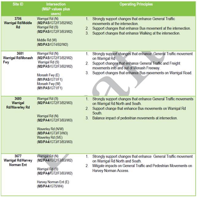
Source: Warrigal Road Signal Route Review – draft IOPs
Key Findings
A write-up of the IOPs material, broader informing Network Operation Planning activities and interview discussions is provided below.
Theme | Response |
How is "network operation planning" defined and what should it be used for | - Traffic management
- Support Movement & Place priorities
- Support collaboration between various traffic management authorities to ensure consistency with the overall network strategy
- Guide the design and operation of traffic systems
|
The development processes / steps / stages and timings | Steps for a Signal Route Review consist of the following: - Define the scope
- Define the network context
- Define the local context
- Establish existing performance
- Consult to set operation principles
- Develop improvement options
- Assess options against principles
- Implement
- Evaluate and report.
General process to all NOP activities relates to the following Movement & Place Option Assessment steps: - Step 1 - Define the network context
- Step 2 - Define the local context
- Step 3 - Set design principles
- Step 4 - Assess option against principles.
|
Where it fits in the overall network development and management process | - Movement & Place to inform each level of development and management, as well as bring all the key stakeholders together.
- It is noted that Signal Route Reviews are only one part of the broader NOP (and M&P) activities, i.e. NOP should also cover / integrate the full transport system.
- Gap analysis able to be used to inform programs and prioritise works.
- NOPs for major projects are being developed to achieve fit and align / integrate other project delivery requirements.
|
How it aligns / integrates with approval and funding processes | - NOPs are required as part of Business Cases to help ensure strategic and network alignment / fit.
- The weightings within the strategic performance gap analysis, referred to as the Strategic Focus Score (SFS), gives some consideration to the financial benefits each mode provides (same weighting from NFA tool are currently being used In the SFS tool).
|
How it aligns / integrates with network and project planning approaches | - Integrated into the Movement & Place framework
- Gap analysis, as it relates to the aspirational / minimum performance target Movement & Place classifications and their existing level of operation
- Agreed NOPs forms part of major project requirements
- IOPs reflect the gap analysis and need to support given modes to achieve the desired level of operation
|
What the strategic objectives are and where did they come from | - Movement and Place defines the strategic intent for how a road network should be managed, function and perform in accordance with the objectives set out in the Transport Integration Act 2010, Victoria’s principle transport statute.
- There is opportunity to reflect strategic objectives through adjustment weightings in the SFS, as long as they relate to movement, place, road safety or environment.
|
What the performance indicators are and where they come from | Performance Indicators are derived from Movement & Place principles and cover: - Movement
- Place
- Road safety
- Environment.
Network strategy and sub-regional network plans feed into M&P and this strategic intent informs the performance indicators. Movement & Place classifications are applied to set the future minimum target performance. Existing and future minimum target performances is measured by LoS. The Gap between existing and future LoSs have weightings applied to reflect their relative performance, importance, etc., and then inform what the 'performance Gap' is. |
Who the development team members should be | - The teams vary based on project scope and complexity.
- For Signal Route Reviews, the project team consists of Signal Operation personnel at the Department of Transport (DOT) with support from Network Planning.
|
Who should implement NOPs | - The implementation team / delivery approach varies based on project scope and complexity.
- Signal Route Reviews are generally implemented by the Signal Operation team at DOT (typically short-term actions). Those not able to be delivered through Signal Operations (due to capability, responsibility and / or funding) are passed onto the relevant department.
|
How should it be implemented | These also vary based on project scope and complexity, but in terms of the Signal Route Reviews: - Short-term actions (low cost and signal programming related) are implemented by Signal Operation
- Medium- and long-term actions (due to capability, responsibility and / or funding) are passed onto relevant department
- More generally, NOP recommendations are implemented on a per project / program basis.
|
What modes have been considered | - General traffic
- Freight
- Tram
- Bus
- Cycling
- Walking
- Interchange between modes
- Tourists
It should be noted that Place, Safety and Environmental are also considered in a similar vain to the above modes and users. |
What network typologies and settings are relevant | - The Movement & Place Framework has a network level basis and input to projects and programs, even if they are corridor based like Signal Route Reviews.
- Signal Route Reviews relate to corridors that are highly controlled by signal operation and coordination.
|
Engagement recommendations | Councils are engaged to help agree on Intersection Operating Principles (IOPs). They are also provided the draft reports indicating proposed actions to review and comment on. |
Planning and Assessment tools and modelling approaches | - Movement & Place classifications across the network are available through vMaps (State Government GIS platform).
- The current strategic level performance gap, known as the SFS, is determined by converting the LoS into values and calculating the difference between the existing and aspirational / minimum target performance LoS. A weighting is then applied according to the mode’s M&P classification. The resulting ‘score’ is used to provide a relative comparison of performance gap across the network.
|
Required input evidence and data | - All data needed to determine the LoS for each mode and place factor.
- A lot of the macro data that determine the M&P classifications and SFS has already been collated / estimated and processed (available through vMaps).
- Level of data quality and confidence is not indicated.
|
Monitoring, feedback, update, etc. processes | - General process to NOP activities does not include a monitoring, feedback, etc. step.
- There is an evaluate and report step with Signal Route Reviews. Moreover, it is understood that they are being continuously completed, so each corridor is expected to be reviewed each 3-4 years.
|
Documents
The documentation provided as part of this case study included the following:
- Warrigal Road Signal Route Review – draft IOPs, VIC DOT, March 2020
- Movement and Place - Traffic Signal Operation Guide, VicRoads
- Movement and Place – Using Option Assessment, VicRoads