Network framework / road use hierarchy
Network modal hierarchy / classification frameworks form a key input to the NOP process. This approach links strategic intent to operational decisions, and helps engagement with urban designers and town planners. Historically, the most widely adopted approach was the SmartRoads Framework, but this has now been replaced by the Movement and Place Framework.
SmartRoads is a network operation planning framework. It provides guiding principles that allocate desired road use by transport mode and time of day across the arterial road network (i.e. the state controlled surface transport network). The resulting modal network arrangements are referred to as the Road Use Hierarchy (RUH). The RUH provides integrated but holistic networks for each mode of transport that connect key trip generators and destinations. This helps guide planners about the role and function of each road. The RUH includes a desired Level of Service for each mode along each link, which provides an understanding of their relative priority and any needs for improvement.
There is now a shift away from SmartRoads towards Movement and Place . New South Wales, Victoria and South Australia are already implementing their own Movement and Place based Frameworks, with New Zealand and Western Australia currently developing theirs. As Movement and Place is relatively new, there is currently limited alignment across jurisdictions.
The Movement and Place Framework is considered to be an improvement and evolution of the SmartRoads Framework because it:
- directly considers place and land-use
- helps transport planners, urban designers and town planners to agree on a shared vision
- has the potential to move away from ‘predictand provide’ towards ‘vision and validate’.
Case studies
The network modal hierarchy / classification frameworks adopted in the Case Studies are indicated in the table below.
Case study | Area | Corridor | Jurisdiction | Network Framework Type Adopted |
|---|---|---|---|---|
X | Western Australia | Road Classification | ||
X | New Zealand | SmartRoads based | ||
X | New Zealand | SmartRoads based | ||
X | Tasmania | SmartRoads based | ||
Warrigal Road Movement and Place – Intersection Operating Principles | X | Victoria | Movement and Place |
Network framework types
At the time of writing, no specific application of the Movement and Place Framework can be recommended as best practice. However, examples of adoption are presented below.
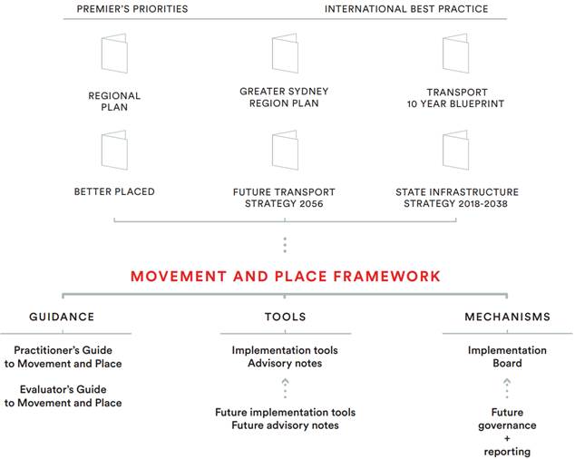
NSW Movement and Place Framework
NSW Movement and Place Framework is set out in NSW Practitioner’s Guide to Movement and Place (2020), with an overview provided in the figure below.
NSW Movement and Place Framework Overview
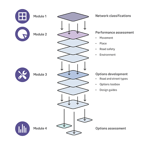
VIC Movement and Place Framework
VIC Movement and Place Framework is set out in VIC DOT Movement and Place in Victoria (2019), with an overview provided in the figure below.
NZ transitioning process
New Zealand is transitioning their SmartRoads based network hierarchies to Movement and Place based network classifications. This process is illustrated in the figure below.
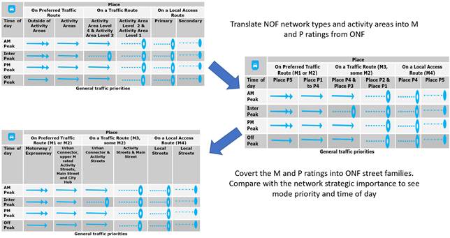
Source: NZTA Presentation – May 2020, Austroads National Task Force NOP Workshop
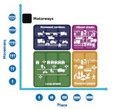
Street families
The Movement and Place Framework enables the identification of street families or types. As VIC DOT Movement and Place in Victoria (2019) states, the key benefits in developing street families or types is:
“By grouping movement and place classifications into road and street types, transport links can be compared to examples of roads and streets successfully operating in similar contexts in the existing network. This helps to determine the nature and scale of change required to transform the link so that it becomes closer to its aspirational state. Street types are discussed further in this module.”
The way street families or types have been identified in NSW, VIC and NZ are illustrated in the figures below.
NSW street families / types identification matrix
Source: NSW Road Network Planning Urban Design ‘Place’ Character Assessment Methodology and Guidance Notes (2019)
VIC street families / types identification matrix
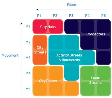
Source: VIC DOT Movement and Place in Victoria (2019)
NZ street families / types identification matrix in rural and urban settings
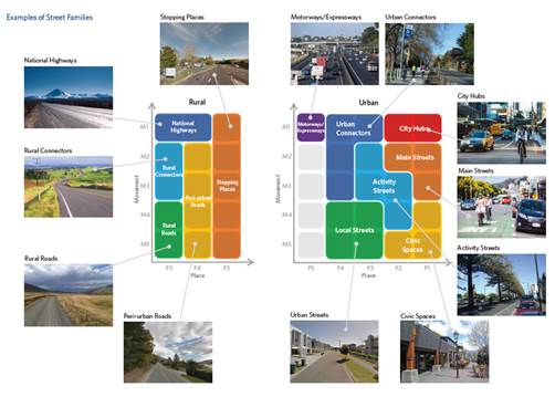
Source: NZTA Presentation – May 2020, Austroads National Task Force NOP Workshop