Study area typology and extent
Corridor and area-based network operation planning approaches are common and suitable for urban and rural settings. The choice of an area or corridor-based approach depends on the structure of the adjacent network and the level of influence of land use activities and access.
Network operation planning can be applied to corridors and areas in urban and rural settings.
Area: Consists of a defined geographic space and all the transport routes within it. An area focus, rather than a corridor focus, is often required in urban planning to best account for the highly complex interactions (intersecting routes and dispersed population, activities, trip origins and trip destinations) in urban settings.
Corridor: Comprises the parallel/competing modal routes between two locations (e.g. road and rail routes between two capital cities). A corridor is multi-modal where more than one mode operates and is mono-modal where only a single mode operates (e.g. in many rural settings).
The figure below indicates when areas or corridor-based NOPs are most relevant. It is based on road function guidance from Austroads and street family classifications from New South Wales.
Area vs corridor study area selection guidance
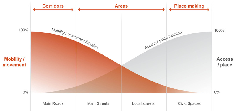
Source: Based on Figure 1.2 from Austroads Guide to Traffic Management Part 5: Link Management, and NSW Street Family Classifications.
Note: there is a difference between corridor-based NOPs and Signal Route Reviews. Signal Route Reviews tend to occur at the place / link and node levels with a purely operation focus. They are often a recommendation from, or informed by, the higher-level area or corridor-based NOP priorities and desired service levels.
Source material
Source | Study area typology and extent |
|---|---|
Phase 2 - Network and Services Definition in Figure 2 p18 and write-up p20 states: "Definition of the geographic area, functional road hierarchy and configuration of the existing and planned road network to be analysed are defined in this phase. The desired approach should be to focus analysis on strategic corridors or areas and include arterial and regional roads, including higher order local roads." Phase 6 - Implementation of Network Operation Plans in Figure 2 p18 and write-up p26-27 states: "Development of network operation plans should focus on the interactions between initiatives, on corridor (and to a lesser extent, off-corridor impacts)" | |
Guide to Traffic Management Part 4: Network Management Strategies (2020) | Limited guidance is provided. However, Section 5.5 - Network Strategies p64-65 states: "Network strategies may be applied to areas, corridors, routes or control points in a road network. Defining homogeneous sub-networks can be a useful way of breaking larger road networks down into manageable areas for the development of strategies." Also, the example operation and management plans in Figures 5.6 to 5.8, p66-67, relate to local regional areas. |
Source | Study area typology and extent |
|---|---|
The Framework Section p11-20, Box 2: Transport system elements p15 states: "An area consists of a defined geographic space and all the transport routes within it. An area focus, rather than a corridor focus, is often required in urban planning to best account for the highly complex interactions (intersecting routes and dispersed population, activities, trip origins and trip destinations) in urban settings." | |
Road Network Planning Urban Design ‘Place’ Character Assessment Methodology and Guidance Notes (2019) | Appendix A, Section 1.1 - Introduction p5 indicates the 'Movement and Place' approach has been developed to assess corridors, as part of the corridor strategic planning activities. Appendix A, Section 1.5 - Road Network Planning p9 refers to a network plan, but also mentions the establishment of a corridor vision and objectives states. |
MRWA Network Operation Planning Framework (2014) | Section 2.6 - Phase 5: Operation Strategy p11-12 states: "The operation strategy may be applied to areas, corridors, routes, links or specific control points in a road network. The strategy should be developed for each relevant mode for each section of the network. Defining homogeneous sub-networks can be a useful way of breaking larger road networks down into manageable areas for the development of a strategy." |
Bringing it all together p23-35 indicate that the Framework can be applied to the following types of areas:
| |
A comparative study of four network operations planning frameworks guidelines (2010) | Phase 2 – Define network (or sub-network, corridor, route, road or link as appropriate) section p18 states: "Defining network involves identifying the Potential Impact Area (PIA) including the road hierarchy within PIA, and collecting relevant road configuration details, standards and road-use data. The road network should also include any future improvements to the network within and immediately outside PIA. The Potential Impact Area is essentially a sub-network where the operational impact of any proposed Management & Operations options is likely to fall within and is subject to judgement depending on the characteristics of the network, drivers of the Network Operation Plan to be prepared and available funding for the Network Operations Plan. Likelihood of funding for implementation of the resulting Management & Operations options and the nature of operations coalitions to be established may also have some bearing on the determination of PIA.” |
Section 2 - Managing the road network and the MTS p8-9 indicates the strategy is a network level document but will inform the development of sub-regional and local borough areas. | |
Section 2 - Model Corridors p9-40 presents three fictional corridor examples in the following contexts:
| |
Section 2.5 - Operating Levels and Network Ranking p 53-57 provide operational management guidance around the following corridor types:
|
Source | Study area typology and extent |
|---|---|
MRWA has a corporate focus around keeping the main road network operating efficiently and safely, so while they will consider area effects, their primary focus is generally a corridor one. | |
Auckland region – area and corridor based operation plans developed. | |
The City of Hamilton (i.e. divided into four quadrants and the CBD) | |
| |
Warrigal Road Movement and Place – Intersection Operating Principles |
|