How Automated Vehicles will Interact with Road Infrastructure
This study was carried out to investigate the infrastructure needs of automated vehicles now and in the future. The study methodology included training state-of-the-art artificial intelligence (AI) algorithms to help accurately localise the vehicle and recognise Australian road signs, road lines and traffic lights. For the first time in Australia the methodology also extended to compare results with and without the use of annotated prior maps (sometimes referred to as high-definition maps). The study data was gathered along multiple routes in and around Brisbane.
Start and end dates: August 2018 to January 2020
Lead organisation: Queensland University of Technology
Location: Brisbane, Queensland, Australia
Additional organisations: Queensland Department of Transport and Main Roads, iMOVE CRC
Contact person: Professor Michael Milford
Link to project website: How automated vehicles will interact with road infrastructure
Included technologies
- Automated driving and driver support: highly automated driving
Project stages
- Testing for specific performance
Included locations
- Urban motorway
- Urban high traffic / high speed roads
- Urban low traffic / low speed roads
- Rural motorways and divided highways
- Rural main highways
- Rural lower volume sealed roads
Benefits directly sought by the project
- Increase knowledge and experience of the technology
Project scale
- 1 vehicle
Further details on included technologies
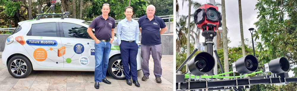
- Velodyne VLP‐32C LIDAR
- Ladybug5+ camera (360⁰ camera)
- GigE uEye FA Industrial Cameras (3x)
- RTK-GPS
- Image processing neural networks
Objectives
- Prepare for and accelerate the emergence of AV technologies onto Australian roads
- Respond to the national call for priority trials and research of transformative transport technologies
- Grow governments’ technical and organisational readiness for deployment of AV technologies on Australian roads, with focus on understanding road asset (signs and lines) readiness for AVs
- Demonstrate and evaluate AV sensing and recognition technologies in an Australian context to support public awareness and uptake.
Research questions that the project aims to address
- How will existing infrastructure (signage, line markings) affect the major operational capabilities (lane keeping, localisation, hazard signage, etc.) and the reliability of an automated vehicle (AV)?
- How will existing built and signed infrastructure affect the accurate (automation enabling to a few centimetres precision) positioning capability of an automated vehicle?
- What types of infrastructure improvements could address shortcomings identified in this study?
- How will the answer to the above three questions change depending on the technology solution deployed on the automated vehicle, with a primary focus on the spectrum of possible range-based (laser, radar) solutions versus primarily vision-based (MobilEye® for example) solutions?
Lessons learned to inform the conduct of trials
Developing a custom, non‐autonomous research car platform – the ZOE 1 car – involved significant resources, an engineering team with significant experience with field‐deployed platforms, sensing, and hardware in general, much back and forth with vendors, insurance, clearance to drive on public roads, and repeated iteration to debug a range of issues in order to produce a reliable dataset acquisition platform.
Lessons learned that inform future technology deployments
Signs:
- Camera vision with trained/modified open source algorithms resulted in poor sign detection.
- Around 40% of speed, give-way, no right turn, pedestrian crossing, and speed hump signs were accurately detected, however 120% (more than the total number of signs) were falsely detected or categorised on arterial and collector roads. Accurate detections halved at night.
- Use of a prior map - a map that is annotated with sign information in addition to camera detection on a sample of the data resulted in a significant improvement (around 95% accuracy).
Longitudinal lines:
- Trained/modified open source algorithms were reasonable – able to fill in short missing sections or poorly defined lane marking, but struggled to travel through intersections. The cameras worked well at night – better than in daytime conditions.
- Common line issues included, intersections, adjacent roadway lines (stop-bars, pedestrian crossings), poor pavement lines such as ghost lines or stick and stomp, cracked pavements, and water on the road.
Traffic lights:
- Around 68% were accurately detected and 85% falsely detected on arterial roads. Performance during the day was better than at night.
- Some of the detection errors were produced by falsely detecting adjacent railway signals, light displays at service stations and wet camera lens.
- Using prior map resulted in a significant improvement (around 98% accuracy).
Vehicle positioning:
- Camera-based performance was found to be generally high, except at night and rural environments where unique visual landmarks are less frequent. Some of the challenges identified are; repetitive nature of the environment, non-uniform lighting variations and images with motion blur.
- LiDAR based method showed impressive results, with a vehicle positioning accuracy of within one metre. As expected the performance was not affected by day or night conditions. Some of the challenges include: transient objects such as other vehicles, and changes in the environment such as the removal of near static objects, for example scaffolding.
- It is likely that with the availability of prior maps of the environment, a fused camera and LiDAR based positioning system will be able to provide adequate information under most conditions for accurate vehicle positioning.
- The study suggests without LiDAR or HD maps it is unlikely to provide satisfactory localisation performance for autonomous driving - the accuracy of signs and lines detection and categorisation is significantly improved with HD maps.
With both LiDAR and an HD map, only minimal changes to the physical infrastructure may be required and an infrastructure manager will likely have a role in providing supporting information for HD maps such as an intersection layout. An infrastructure manager should also be aware of the negative impact of repetition in infrastructure design, and the removal of key infrastructure which may be used by vehicles for accurate positioning. Without LiDAR/HD map, an infrastructure manager will likely need to harmonise signs, remove sign obscuration and improve illumination, add line markings within intersections, and add clearer line markings within roadworks.
Links to project lessons learned and / or benefit assessment reports
Last updated: May 2021.